
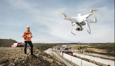
Africa is measuring itself at a pace and scale without historical precedent. National land registration programmes are formalising tenure for tens of millions of parcels. Infrastructure investment is building roads, dams, railways, and power networks at rates that demand continuous survey support. Mining operations need production measured accurately enough to satisfy auditors, while cities are building the spatial data infrastructure that urban planning depends on.
The survey capacity required to complete this work using ground methods alone does not exist. There are not enough surveyors, not enough equipment, and not enough hours within programme timelines to cover the required areas at the required accuracy using terrestrial surveying alone.
Drone surveying resolves that arithmetic. A DJI Matrice 350 RTK with Zenmuse P1 can cover approximately 3 km² in a single flight at approximately 3 cm accuracy without ground control points. A Matrice 400 with Zenmuse L3 can cover up to 100 km² per operating day. Work that may take a ground crew a month can be completed by an aerial survey team in a week, at comparable or better accuracy and with a complete measured surface rather than interpolation between sampled points.
Aerosmart supplies, configures, and supports the complete DJI geospatial ecosystem across 14+ African countries as an authorised DJI Enterprise dealer.
| Specification | Detail |
|---|---|
| Survey Platforms | Matrice 400 · Matrice 350 RTK · Matrice 4E |
| Photogrammetry | Zenmuse P1 · 45MP full-frame |
| LiDAR | Zenmuse L2 · Zenmuse L3 |
| Multispectral | Mavic 3 Multispectral |
| RTK Base Stations | D-RTK 3 · D-RTK 2 |
| Horizontal Accuracy | 3 cm without ground control points |
| Vertical Accuracy | 3 cm at 120 m with Zenmuse L3 |
| Photogrammetry Coverage | 3 km² per flight |
| LiDAR Coverage | Up to 100 km² per day |
| LiDAR Returns | Up to 16 returns per pulse |
| Processing | DJI Terra · DJI Modify · PIX4Dmatic · PIX4Dsurvey |
| Offline Capability | Complete processing pipeline with no internet connectivity required |
| Autonomous Survey | DJI Dock 3 · DJI Dock 2 |
| Delivery Markets | 14+ African countries |
Land surveying, cadastral documentation, and urban planning surveys produce the orthophotos, terrain models, and boundary data that national land administration and municipal planning depend on.
Progress monitoring, earthwork volume calculation, BIM data capture, and heritage documentation support the infrastructure and building programmes expanding throughout African markets.
Stockpile volumetrics, open-pit geometry, high-wall and facade mapping, asset inspection, and site-safety monitoring support mining operations in Zambia, the Democratic Republic of the Congo, Ghana, Zimbabwe, Tanzania, and Mozambique.
NDVI and NDRE crop-health mapping supports variable-rate application, while LiDAR canopy measurement supports forestry inventories and carbon-stock assessments.
Traditional aerial photogrammetry requires ground control points: surveyed markers distributed across the mapping area, each measured to known coordinates and used to constrain the photogrammetric solution to its real-world position. Establishing these points is slow, and across much of Africa it can be difficult because national survey-control networks may be absent, incomplete, or physically inaccessible.
RTK-corrected aerial surveying removes this requirement. A D-RTK 3 or D-RTK 2 base station broadcasts corrections to the aircraft throughout the flight, and every captured frame carries a centimetre-accurate position at the moment of capture. The resulting solution is constrained by the aircraft's positional accuracy.
The practical consequence is that a survey team arriving at a remote site can begin survey-accuracy missions within minutes instead of spending a full day establishing control. For programmes where throughput determines delivery against national timelines, that compression is decisive.
Centimetre-level survey accuracy for professional mapping and measurement workflows.
High-throughput aerial data capture for large survey areas and infrastructure corridors.
RTK correction supports accurate georeferencing without establishing physical ground markers across the site.
Survey data can be processed without internet connectivity at remote project locations.
01 Authorised DJI Enterprise Dealer
Genuine products, original warranties, current firmware, and
documentation valid for aviation authority registration.
02 Delivery Across 14+ Countries
Direct shipping with export documentation and import duty guidance
for every destination.
03 Coordinate System Configuration
Output configuration for your national survey framework, ensuring
data imports directly into existing GIS and cadastral systems.
04 Accuracy Requirement Consultation
Payload and base-station selection matched to the accuracy your
deliverable actually requires.
05 Post-Sale Support and Servicing
Dubai-based repair, maintenance, and remote diagnostics are
available to clients across supported markets.
06 Survey and LiDAR Training
Complete workflow training through Aerosmart Academy, available
on-site across 14+ African markets.
07 Full System Configuration
Aircraft, payload, RTK base station, processing software, and
training supplied as a complete working survey capability.
Using the Matrice 350 RTK with Zenmuse P1 and a D-RTK base station, horizontal accuracy of approximately 3 cm can be achieved without ground control points. The Zenmuse L3 can achieve approximately 3 cm vertical accuracy at an altitude of 120 m.
No. RTK correction from a D-RTK 3 or D-RTK 2 base station constrains the aircraft position throughout the flight, producing survey-accurate georeferenced data without ground markers.
Photogrammetry is suitable for open, unvegetated surfaces and produces detailed orthophotos and volume measurements. LiDAR is suitable where vegetation covers the ground, fragmented geometry creates shadows, or canopy penetration is needed. Many survey operations use both.
The Zenmuse P1 can cover approximately 3 km² per flight. The Zenmuse L3 mounted on the Matrice 400 can cover up to 100 km² per operating day, depending on terrain and mission conditions.
Yes. DJI Terra can process photogrammetry, LiDAR, and multispectral data entirely offline, which is essential for remote African survey sites without reliable mobile connectivity.
Yes. Outputs can be exported in LAS, LAZ, GeoTIFF, DXF, SHP, and LandXML formats compatible with major GIS, CAD, BIM, and mine-planning platforms.
Yes. Aerosmart Academy delivers Drone Survey and Mapping and LiDAR Processing programmes on-site across 14+ African markets or at the Nairobi Academy.
Aerosmart supplies African markets including Kenya, Nigeria, Ethiopia, Ghana, Tanzania, Uganda, Rwanda, Zambia, Mozambique, Malawi, Zimbabwe, Namibia, Mali, Chad, Togo, Sierra Leone, The Gambia, Seychelles, the Republic of the Congo, the Democratic Republic of the Congo, and Côte d'Ivoire.

Fill in your details below and our team will get back to you with a personalised quote.