
Vertical surfaces present a unique challenge for aerial surveying. A downward-facing camera can map horizontal ground surfaces effectively, but it cannot fully capture vertical faces, overhanging geometry or the complex three-dimensional structure of building facades and mine high walls. These surfaces require carefully planned oblique or horizontal image capture, consistent standoff distance and complete coverage from top to bottom.
In African mining and construction environments, open-pit high walls and tall-building facades present similar data-capture challenges. Ground-based survey methods may require personnel to work on ropes, elevated platforms or hazardous mine benches. DJI enterprise drones can capture detailed vertical-face geometry while reducing the need for survey and inspection teams to work at height or close to active mining areas.
Open-pit mines across Zambia, Ghana, Zimbabwe, the Democratic Republic of the Congo, Mozambique and Tanzania include vertical and sub-vertical rock faces that may extend from tens to hundreds of metres in height. Accurate high-wall geometry supports pit-volume calculation, slope-stability assessment, blast planning and mine reconciliation.
Traditional high-wall surveys often rely on total-station measurements of bench crest and toe lines, with the geometry between measured points being interpolated. This process can be slow and may expose survey personnel to rockfall, unstable ground and active mine traffic. Drone-based surveys can capture the complete face rather than only selected points.
A DJI enterprise platform equipped with a compatible LiDAR or photogrammetry payload can follow a planned vertical-face coverage pattern while maintaining a controlled distance from the high wall. The resulting point cloud or 3D model can document bench faces, irregular wall geometry and the complete profile from crest to toe. Final accuracy depends on flight planning, payload selection, survey control, terrain and processing methods.
For slope-stability and geotechnical assessment, a detailed high-wall point cloud can support the interpretation of visible rock joints, bedding planes and fault structures. This provides geotechnical teams with valuable spatial information while reducing the need for manual face mapping from ropes or elevated platforms.
For blast-design verification, post-blast high-wall geometry can be compared with the planned face position and angle. This helps teams identify back-break, under-break and other deviations that may inform adjustments to future drilling and blasting operations.
For Africa's urban construction and property-management sectors, drone facade surveys can provide detailed as-built documentation of cladding systems, window installations, structural elements and decorative features. These datasets can support condition assessments, maintenance planning, renovation design and insurance documentation.
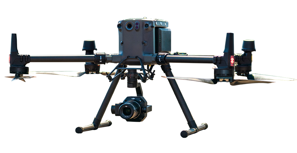
The DJI Matrice 350 RTK equipped with the Zenmuse P1 can capture high-resolution facade imagery from multiple angles. The imagery can be processed into a detailed photogrammetric 3D model showing panels, joints and visible surface features. Final model quality depends on image overlap, lighting, flight distance, survey control and processing settings.
For commercial buildings in Nairobi, Lagos, Accra, Kigali and other African cities, drone-based facade documentation can reduce the time and access requirements associated with rope-access or scaffold-based inspection methods.
DJI enterprise drones can follow planned vertical-face flight paths while maintaining a controlled distance from the mine high wall. Oblique-image capture or LiDAR scanning can document the complete face geometry, including bench dimensions and visible geological features. The resulting point cloud or 3D model can support slope assessment, blast planning and mine surveying without requiring personnel to access hazardous bench areas.
Yes. The DJI Matrice 350 RTK equipped with the Zenmuse P1 can capture high-resolution images of building facades from multiple angles. The imagery can be processed into detailed photogrammetric 3D models for as-built documentation, condition assessment, inspection planning and renovation design.
The DJI Matrice 400 paired with a compatible LiDAR payload is suitable for high-wall point-cloud capture and slope-monitoring workflows at large mining sites. The DJI Matrice 350 RTK with the Zenmuse P1 is suitable for photogrammetric high-wall surveys and detailed building-facade modelling. The final platform and payload should be selected according to the required accuracy, wall geometry, survey area, flight conditions and deliverable format.

Fill in your details below and our team will get back to you
with a personalised quote.