
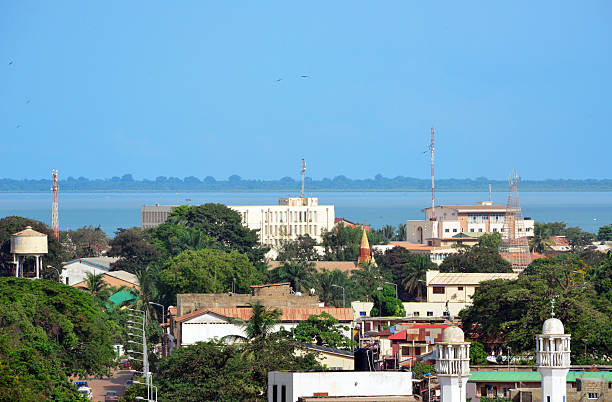
The Gambia is defined by its river. Agriculture concentrated along the River Gambia—groundnuts, rice, cashew and horticulture—a coastal tourism sector, and fisheries along the Atlantic front create the country's core drone opportunities, alongside infrastructure and the Port of Banjul. Civil aviation is administered by the Gambia Civil Aviation Authority (GCAA), which authorises drone operations; the country's dedicated drone framework is developing, so authorisation is obtained on application and current requirements should be confirmed directly before any deployment.
What separates a productive fleet from an idle one is the support around it: correct platform selection, clean import and authorisation paperwork, trained pilots, and a reliable service pathway. Aerosmart Africa is built around that full lifecycle rather than a single sale.
Aerosmart Africa supplies the complete DJI range into The Gambia as an authorised DJI Enterprise and DJI Agriculture dealer, with delivery to Banjul, Serrekunda, Brikama and nationwide, GCAA regulatory guidance, and on-site training.
Agriculture. Groundnuts, rice, cashew and horticulture along the River Gambia present spraying, spreading and crop-health mapping requirements where aerial application delivers labour savings and better coverage than manual methods.
River and Water Management. River Gambia monitoring, irrigation-scheme survey and flood assessment generate mapping and monitoring demand along the country's central artery.
Tourism and Coastal Media. The coastal tourism sector generates aerial-content demand for resorts and destination marketing under GCAA authorisation and privacy rules.
Fisheries and Coastal Survey. Atlantic fisheries and coastal-erosion monitoring create repeat-survey requirements suited to RTK mapping platforms.
Infrastructure and Ports. Road development, urban growth around Serrekunda and Brikama, and the Port of Banjul generate survey and progress-monitoring demand.
Land Administration. Parcel documentation across fragmented smallholder terrain benefits from the throughput aerial survey delivers over terrestrial methods.
Drone operations in The Gambia are administered by the Gambia Civil Aviation Authority (GCAA). The Gambia's dedicated drone rules are developing; the points below are practical guidance, not legal advice, and current requirements must be confirmed directly with the GCAA before operations.
Authorisation. Drone operation requires GCAA authorisation, obtained on application with equipment details, intended use and operator information.
Registration / Marking. Aircraft marking and identification requirements apply under the national civil aviation framework; the GCAA should be consulted on the current registration requirement for remotely piloted aircraft.
Import Authorisation. Drone importation should be cleared with correct documentation to avoid detention at entry.
Good-Practice Operating Limits. Pending confirmation of specific national limits, operators should keep the drone within visual line of sight and in daylight, maintain a safe separation from people, property and vehicles, and avoid airports, military and government sites and Banjul International Airport's airspace.
What Aerosmart Provides. A written Gambia-specific regulatory brief covering the GCAA authorisation process, current registration and marking requirements, import clearance and operating limits, plus documentation support with every purchase.
For agriculture, the Agras T50 covers groundnut, rice and horticulture blocks efficiently, while the T25 suits smaller holdings and service providers; the Mavic 3 Multispectral maps crop health for variable-rate planning. For river, land and infrastructure survey, the Matrice 350 RTK with Zenmuse P1 delivers photogrammetry to roughly 3 cm with a D-RTK base station, and the Zenmuse L2 adds LiDAR where vegetation defeats photography. For coastal and structure inspection, the Matrice 30T brings compact thermal and zoom capability. Salt exposure near the coast is factored into Aerosmart's maintenance planning.
Aerosmart supports operators nationwide, with concentrated demand in Banjul for government, ports and infrastructure; Serrekunda and Brikama for urban and coastal operations; and the agricultural regions along the River Gambia, including Farafenni. We deliver, configure, register and support fleets wherever your operation is based, and our training teams travel to site.
Aerosmart Academy delivers on-site training across The Gambia, including Banjul, Serrekunda, Brikama and the agricultural regions, structured around GCAA requirements and delivered on genuine DJI enterprise platforms. Training covers flight operations, agricultural and survey workflows, data processing, and the authorisation and import steps operators need to fly legally and productively.
01 Authorised DJI Enterprise Dealer. Genuine product, warranty, firmware and documentation.
02 The Gambia Delivery. Banjul, Serrekunda, Brikama and nationwide with customs documentation.
03 GCAA Regulatory Guidance. A written Gambia-specific brief on the authorisation process.
04 Agricultural Configuration. Agras selection for groundnuts, rice and horticulture.
05 Survey Configuration. RTK and LiDAR selection for river, land and coastal survey.
06 On-Site Training. Aerosmart Academy delivers anywhere in The Gambia.
07 Service Coordination. Remote diagnostics, repair routing and DJI Care claims managed directly.
Aerosmart Africa is an authorised DJI Enterprise and DJI Agriculture dealer supplying across The Gambia with delivery to Banjul, Serrekunda, Brikama and nationwide.
Yes. Drone operation requires GCAA authorisation. Because the dedicated framework is developing, current requirements should be confirmed directly with the GCAA, and Aerosmart's brief guides you through the process.
The DJI Agras T50 covers groundnut, rice and horticulture blocks efficiently, while the T25 fits smaller holdings. The Mavic 3 Multispectral maps crop health.
Importation should be cleared with correct documentation to avoid detention at entry. Aerosmart provides import guidance with every purchase.
The Matrice 350 RTK with Zenmuse P1 for photogrammetry, or the Zenmuse L2 for LiDAR, both with a D-RTK base station for centimetre accuracy.
Yes. Aerosmart Academy delivers on-site training anywhere in The Gambia on genuine DJI enterprise platforms.
Contact Sales@aerosmartglobal.com with your application for a configuration and quote.

Fill in your details below and our team will get back to you
with a personalised quote.