
Long-Endurance Drone Platform With Power-Line-Level Obstacle Sensing
Engineered for Excellence, Designed for Versatility
DJI Zenmuse L3 See Through, Far and True. Available from aerosmart, Authorised DJI Dealer
Authorised DJI Dealer Genuine Product, Full Warranty
950m Detection Range · Dual 100MP Cameras · 100 km² Per Day
Compatible with DJI Matrice 400 exclusively
Delivery Across 14+ Countries With Export Documentation
The DJI Zenmuse L3 is DJI's next-generation high-accuracy aerial LiDAR system, representing a major advancement in long-range drone-based geospatial surveying. It features a 1535 nm long-range LiDAR capable of measuring targets at distances of up to 950 metres, even on surfaces with as little as 10% reflectivity. Combined with dual 100 MP RGB mapping cameras, a high-precision POS system, and a LiDAR engine capable of up to 2 million pulses per second with up to 16 returns per pulse, the Zenmuse L3 enables daily mapping coverage of up to 100 km². It also provides three dedicated scanning modes for linear corridor mapping, vegetation penetration, urban surveying, and powerline inspection—all within a compact payload designed for the DJI Matrice 400.
The DJI Zenmuse L3 combines its 1535 nm long-range LiDAR, dual 100 MP RGB mapping cameras, high-precision POS system, and a 3-axis stabilised gimbal into a single integrated payload, delivering exceptional mapping performance in a compact form factor. When mounted on the DJI Matrice 400, a single flight at an altitude of 300 metres can cover up to 10 km², enabling total daily survey coverage of up to 100 km². LiDAR and RGB imagery are captured simultaneously, allowing operators to generate digital orthophoto maps (DOM), digital elevation models (DEM), colourised point clouds, and detailed 3D models from a single flight mission.
aerosmart supplies and supports the DJI Zenmuse L3 as an authorised DJI dealer across 14+ African countries. Our team helps you select the right system configuration, establish the optimal data-processing workflow, and provides technical support from day one to maximise the performance of your LiDAR surveying operations.
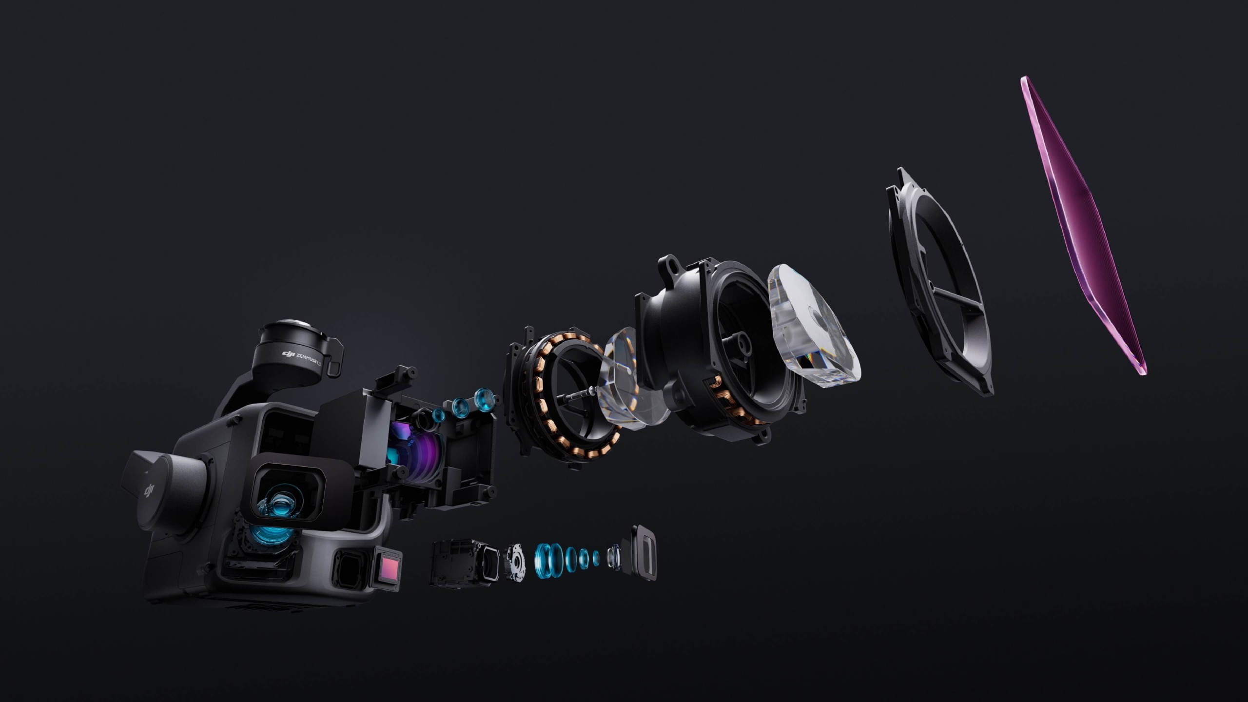
Long-range LiDAR, dual 100MP RGB mapping cameras, survey-grade accuracy, and large-area mapping performance at a glance.
The DJI Zenmuse L3's 1535 nm laser wavelength is the technical foundation of its performance advantage over previous DJI LiDAR systems. The 905 nm laser used in the Zenmuse L2 and earlier systems operates at a shorter wavelength, which limits the maximum power that can be emitted while remaining within applicable eye-safety classifications. At the power levels that 905 nm systems can safely produce, detection range is constrained by both the shorter wavelength and the available pulse-energy ceiling.
The 1535 nm wavelength used by the L3 operates within an eye-safe spectral region where substantially higher laser pulse energy can be emitted without increasing retinal exposure risk. Because this wavelength is absorbed before reaching the retina, the L3 can operate as a Class 1M laser while delivering significantly greater pulse energy than typical 905 nm systems. This higher pulse energy supports longer detection range, stronger returns from low-reflectivity surfaces, improved vegetation penetration, and more reliable detection under the high ambient-light conditions encountered during midday aerial survey missions.
950 m at 10% Reflectivity — The Industry-Defining Range
Ten percent reflectivity is a standard LiDAR test condition used to evaluate detection-range performance. It represents low-reflectance surfaces such as dark soil, asphalt, and certain types of vegetation that absorb most of the incident laser energy. Achieving a detection range of up to 950 metres at 10% reflectivity means that, in typical operating environments where many survey targets have higher reflectivity, the L3 can reliably detect surfaces at altitudes and distances beyond those supported by previous-generation DJI LiDAR payloads.
At up to 2,000 metres on targets with 80% reflectivity, the L3 extends its detection envelope across higher-reflectance surfaces such as concrete, pale soil, and selected infrastructure materials. This expanded range supports higher-altitude survey operations and enables a single flight to cover areas that may previously have required several lower-altitude missions.
Adjustable Pulse Rate — Flexible Performance for Every Mission
The L3's adjustable pulse rate—from 100 kHz and 350 kHz through 1,000 kHz and up to 2,000 kHz—allows operators to balance detection range, point-cloud density, and the number of returns per pulse for each survey application. At 100 kHz, operators can access the maximum detection range of up to 950 metres at a lower point density, making it suitable for high-altitude, maximum-coverage missions. At the maximum 2,000 kHz pulse rate, the L3 produces much denser point clouds at shorter ranges, supporting close-range and high-resolution surveys where spatial detail is more important than maximum detection distance.
2 Million Pulses per Second
The DJI Zenmuse L3 can generate up to 2 million laser pulses per second at its highest pulse-frequency setting. This produces a dense point cloud capable of resolving fine spatial details such as powerline conductors, individual tree branches, building edges, and complex structural geometry that lower-pulse-rate systems may represent as sparse or incomplete point distributions.
The practical value of a high LiDAR pulse rate is the spatial completeness of the resulting point cloud. Higher pulse frequencies increase the number of measurement points captured per square metre at a given flight altitude, helping resolve smaller features, reduce gaps between measurements, and improve the vertical representation of complex objects. This is especially valuable for applications such as powerline inspection, where sufficient point density is required to detect and map narrow conductors and cables reliably.
16 Returns per Pulse — Superior Penetration
At 100 kHz and 350 kHz, the L3 can record up to 16 returns from a single laser pulse, providing advanced vegetation-penetration capability. As a pulse travels through a forest canopy, it can generate separate returns from the upper canopy, intermediate branches, understorey vegetation, ground cover, and the bare-earth surface beneath.
Up to 16 returns per pulse can produce a more complete vertical profile of forested terrain, supporting applications such as forest biomass estimation, carbon-stock assessment, and canopy-height modelling. In mining applications, multiple returns can also help capture the irregular geometry of fragmented rock faces, including recesses, overhangs, and complex surface changes that limited-return systems may not fully represent.
Point-Cloud Thickness — Half That of the Zenmuse L2
The L3 produces a point cloud with approximately half the thickness of the DJI Zenmuse L2, reflecting improvements in ranging precision, laser-beam geometry, and measurement consistency. A thinner point cloud means that detected surfaces are represented with less spatial spread, producing cleaner edges and more precise surface definition in the final dataset.
The combination of a smaller laser footprint, higher pulse energy, reduced beam divergence, and thinner point-cloud structure improves terrain definition and surface-positioning precision. This supports more accurate digital elevation models, cleaner classification of ground and vegetation points, and more reliable representation of complex infrastructure and natural terrain.
The DJI Zenmuse L3 integrates two 100-megapixel 4/3 CMOS mapping cameras, representing a major increase in photographic resolution compared with the Zenmuse L2's single 24MP RGB camera.
Both cameras use mechanical shutters, helping prevent rolling-shutter distortion during forward flight while delivering the image quality, dynamic range, and geometric consistency required for professional orthophoto generation and point-cloud colourisation.
Learn More ↗At a flight altitude of 120 metres, the dual RGB cameras can achieve a ground sampling distance of approximately 1.2 cm. At 300 metres, they can achieve approximately 3 cm GSD.
This image resolution supports detailed orthophoto production at the mapping scales required for professional surveying, while matching the operating altitudes at which the L3 delivers efficient LiDAR coverage, point density, and positional accuracy.
Learn More ↗The dual-camera system provides a combined horizontal field of view of up to 107°, compared with the narrower field of view of the previous-generation L2 camera.
This broader field of view allows the RGB cameras to cover the full LiDAR acquisition swath with a 20% LiDAR side-overlap ratio, reducing the need for separate RGB-specific passes and improving total mission efficiency.
Learn More ↗The L3 captures LiDAR point-cloud data and high-resolution RGB imagery simultaneously during the same mission.
This single-flight workflow provides the data required for digital orthophoto maps, colourised point clouds, elevation products, and detailed 3D models without requiring a separate photogrammetry flight or additional field time.
Learn More ↗Linear scanning produces the most consistent and evenly distributed point cloud across the survey area. Each scan line covers the terrain systematically with predictable point spacing, enabling reliable terrain-model generation across large, flat, and moderately undulating survey areas.
Linear mode is the standard configuration for topographic surveying, cadastral mapping, construction earthwork measurement, and agricultural estate surveys where consistent ground coverage across the complete project area is the main requirement.
Star-shaped mode is designed for forest biomass surveys, canopy-structure analysis, dense urban digital-twin generation, and environments where scanning from a single angle could leave gaps behind vegetation or vertical structures.
Non-repetitive mode supports powerline inspection and complex infrastructure mapping by exposing narrow conductors and irregular structures to a broader range of scan angles. Under standard operating conditions, the L3 can detect 21.6 mm steel-core aluminium stranded wire at 300 metres and 18.4 mm black PVC-insulated wire at 100 metres.
The Position and Orientation System (POS) is the hardware that converts the Zenmuse L3's LiDAR ranging measurements into accurately georeferenced point-cloud positions. Regardless of how precise the LiDAR ranging is, the final positional accuracy of every point depends directly on the accuracy of the POS.
Even a small attitude error can introduce centimetres or even decimetres of positional error at operational survey altitudes, making the POS one of the most important components in any survey-grade LiDAR system.
Learn More ↗The upgraded POS delivers a heading accuracy of 0.02° together with 0.01° pitch and roll accuracy in post-processed mode. These specifications are comparable to dedicated survey-grade IMU systems traditionally used in manned-aircraft LiDAR operations.
This level of positioning performance enables the Zenmuse L3 to achieve approximately 3 cm vertical accuracy at 120 metres and 5 cm vertical accuracy at 300 metres, supporting mapping projects at scales ranging from 1:500 to 1:2000.
Learn More ↗The no-preheat IMU allows survey missions to begin immediately after take-off, eliminating the warm-up period traditionally required for IMU temperature stabilisation before collecting survey-grade data.
During flight, the IMU performs automatic calibration to maintain positioning accuracy throughout the mission without requiring operator intervention, ensuring reliable geospatial data from launch to landing.
Learn More ↗When mounted on the DJI Matrice 400 and operated at a flight altitude of 300 metres, a single DJI Zenmuse L3 mission can cover up to 10 km² of survey area.
With the Matrice 400's extended endurance supporting multiple missions through battery rotation, operators can collect up to 100 km² of LiDAR and RGB survey data within a single working day.
Learn More ↗Coverage of 100 square kilometres per day changes the economics of large-area LiDAR surveying. Regional topographic projects that previously required weeks of field mobilisation can potentially be completed within a single operational day.
Large mining concessions, forestry carbon-baseline surveys, and extensive land-management projects can be captured within significantly shorter field programmes, reducing mobilisation, crew, vehicle, accommodation, and operational costs.
Learn More ↗The L3's 950-metre detection range supports typical survey flight altitudes of approximately 300 to 500 metres, substantially higher than the operating altitudes commonly used with previous-generation DJI LiDAR systems.
Higher flight altitudes increase the ground area covered per flight line, reduce the number of passes required for complete coverage, and shorten the total flight distance for a given survey area. The L3 maintains survey-grade data quality at these altitudes, allowing operators to gain coverage efficiency without sacrificing positional accuracy.
Learn More ↗The DJI Zenmuse L3 integrates seamlessly with DJI's complete software ecosystem, providing an end-to-end workflow from mission planning and LiDAR acquisition through processing, editing, and fleet management.
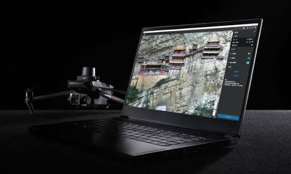
DJI Terra processes Zenmuse L3 LiDAR and RGB datasets into classified point clouds, digital orthophotos, digital elevation models, colourised 3D models, and multiple industry-standard output formats. DJI Terra V5.1.0 and later also support PPK post-processing for projects requiring enhanced positioning accuracy where RTK infrastructure is unavailable. During flight, DJI Pilot 2 provides a real-time point-cloud preview, allowing operators to verify scan quality and identify coverage gaps before leaving the survey site.
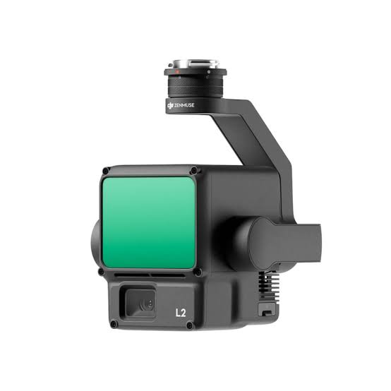
The Zenmuse L2 remains the right choice for survey operations using the Matrice 350 RTK or Matrice 300 RTK, or where its coverage and accuracy specifications fully satisfy project requirements. The Zenmuse L3 is the preferred solution when maximum detection range, the highest point-cloud density, up to 100 km² of daily coverage, dual 100MP RGB mapping cameras, and DJI's most advanced LiDAR performance are required on the Matrice 400.
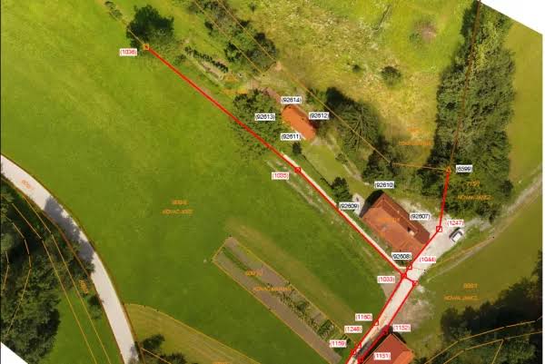
As an authorised DJI dealer, aerosmart provides genuine products, complete system configuration consultation, international delivery, technical support, training, and competitive enterprise pricing.
Every DJI Zenmuse L3 carries an original DJI warranty, current firmware certification, and regulatory-compliant documentation. No parallel imports. No counterfeit risk.
Our team advises on the complete DJI Matrice 400 + Zenmuse L3 + D-RTK 3 Station configuration, including aircraft setup, positioning infrastructure, mission requirements, and the recommended survey workflow before purchase.
We provide guidance for the complete DJI Terra processing workflow, PPK configuration, and DJI Modify subscription activation, helping your team establish an efficient workflow from mission planning to final point-cloud and mapping deliverables.
Direct international shipping with complete export documentation, customs support, and import-duty guidance for every destination market.
Our Dubai-based technical team provides remote system diagnostics, IMU calibration guidance, DJI Terra L3 processing support, firmware assistance, and hardware maintenance throughout the operational life of the system.
Training is available for Zenmuse L3 system operation, scanning-mode selection, DJI Terra's L3 processing pipeline, PPK workflows, and DJI Modify point-cloud editing. Sessions are available remotely and in person.
Contact aerosmart for DJI Zenmuse L3 pricing and complete Matrice 400 + Zenmuse L3 + D-RTK 3 survey system quotations tailored to your operational and data-processing requirements.
Every DJI Zenmuse P1 purchased through aerosmart comes with access to DJI Care Enterprise Plus, covering the payload from its activation date.
All DJI Care Enterprise Plus activations and warranty claims are handled directly by aerosmart, with no overseas routing and no third-party intermediaries.
Unlimited free repairs within the available coverage limit for the full duration of the plan.
Share the available coverage limit across your complete enterprise payload fleet.
Mail-in repairs include two-way shipping, with no hidden repair or logistics costs.
Repairs are completed by DJI-certified engineers using original manufacturer-approved components.
An additional one-year warranty option is available for major payload components.
The DJI Zenmuse L3 is available from aerosmart, an authorised DJI dealer with delivery across 14+ countries. Contact our team for pricing, complete system configuration advice, and availability.
The DJI Zenmuse L3 achieves a maximum detection range of up to 950 metres at 100 kHz on targets with 10% reflectivity under 100 klx ambient light. It can reach up to 700 metres at 350 kHz on the same target type and up to 2,000 metres at 100 kHz on surfaces with 80% reflectivity.
When mounted on the DJI Matrice 400 and operated at a flight altitude of approximately 300 metres, the Zenmuse L3 can cover up to 10 km² in a single flight and up to 100 km² across a full working day with battery rotations and multiple missions.
At a flight altitude of 120 metres, the L3 achieves approximately 3 cm vertical RMSE and 4 cm horizontal RMSE. At 300 metres, it achieves approximately 5 cm vertical RMSE and 7.5 cm horizontal RMSE. At 500 metres, vertical accuracy is approximately 10 cm RMSE, supporting mapping projects at scales from 1:500 to 1:2000 depending on altitude and project requirements.
The L3 provides three scanning modes. Linear mode delivers consistent point distribution for terrain mapping. Star-Shaped mode uses multiple scan angles for forest, vegetation, and dense urban environments. Non-Repetitive mode provides broad angular coverage for powerline inspection and complex structural surveys.
The DJI Zenmuse L3 is compatible exclusively with the DJI Matrice 400. It is not compatible with the DJI Matrice 350 RTK, Matrice 300 RTK, or earlier DJI enterprise aircraft platforms.
The Zenmuse L3 provides up to 950 metres of detection range compared with the L2's 450 metres, up to 16 returns per pulse compared with five, and dual 100MP RGB cameras compared with the L2's single 24MP camera. It also offers a 107° horizontal field of view, up to 10 km² of single-flight coverage, and approximately half the point-cloud thickness of the L2.
The L3 is designed exclusively for the DJI Matrice 400, while the L2 is compatible with the DJI Matrice 350 RTK and DJI Matrice 300 RTK.
Yes. Each DJI Zenmuse L3 purchase includes a complimentary three-month DJI Modify subscription, providing access to point-cloud editing, classification refinement, annotation, and model-preparation tools for completing the L3 data processing workflow.
DJI Zenmuse L3 pricing varies according to the selected system configuration and destination country. Contact aerosmart at africa@aerosmart.ae for an accurate quotation for the payload or a complete survey system including the DJI Matrice 400, D-RTK 3 Station, and DJI Terra software.

Fill in your details below and our team will get back to you
with a personalized quote.