

Earthwork is the foundation of every infrastructure project the cut, fill, and compaction operations that prepare terrain for roads, dams, building foundations, mine haul roads, embankments, and the full spectrum of civil works that Africa's infrastructure investment programme is delivering at scale. And earthwork quantities the volumes of material that have been moved, the volumes that remain, and the comparison between designed and actual earthwork profiles are the numbers that determine project payments, schedule adherence, and contract compliance.
Traditional earthwork volume calculation methods ground survey with total station equipment, manual cross-section measurements, or GPS-based point sampling are slow, expensive per visit, and produce point-based data sets that interpolate between measured positions rather than measuring the complete surface geometry. The errors introduced by interpolation between sparse measurement points, multiplied across the large earthwork areas of an African infrastructure project, produce volume discrepancies that regularly exceed the tolerances of payment verification and contract compliance.
Drone-based photogrammetry and LiDAR survey measures the complete earthwork surface every square metre, continuously, without interpolation gaps at centimetre accuracy, from a single flight that covers the full site area in a fraction of the time that ground survey methods require. The result is earthwork volume data that is more accurate, more comprehensive, and produced more rapidly than any ground-based alternative.
Africa's major earthwork projects span enormous areas and operate in logistical environments that make frequent ground survey visits expensive and disruptive. Road construction projects through Ethiopia's highlands and Tanzania's interior involve earthwork operations across tens of kilometres of active construction corridor where surveyor access to the active working face is both logistically complex and safety-constrained by operating heavy equipment. Dam foundation excavations in Kenya, Uganda, and Zambia involve earthwork volumes in the tens of millions of cubic metres where payment verification requires accurate measurement at defined intervals throughout the construction programme.
The consequence of inaccurate earthwork measurement is financial either the contractor is underpaid for completed work, creating a contractual dispute that delays the project, or the client overpays for quantities that were not completed, creating an audit finding that jeopardises donor funding continuation. Accurate, verifiable, regularly produced earthwork data protects both parties from the measurement uncertainty that sparse survey point methods inevitably introduce.
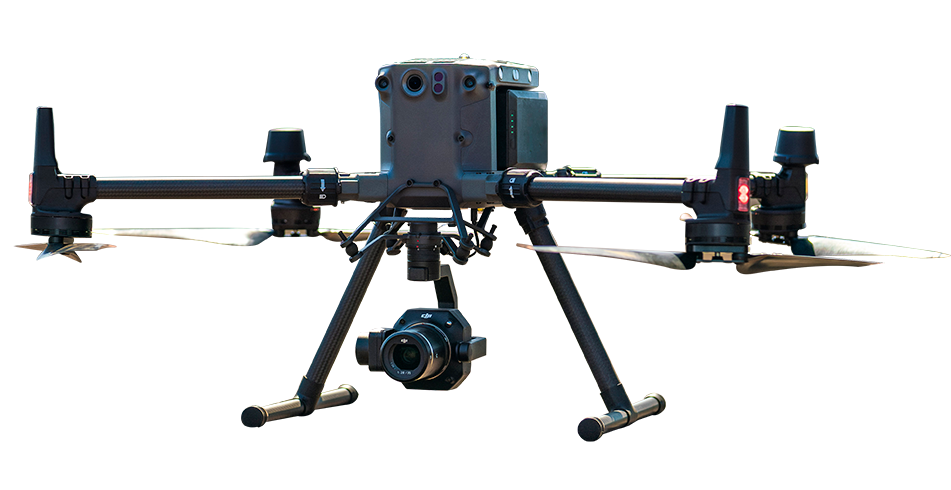
The standard earthwork volume survey system for African construction projects the Matrice 350 RTK's RTK-accurate positioning paired with the Zenmuse P1's 45MP full-frame mechanical shutter camera produces the dense, accurate image dataset that photogrammetric reconstruction converts into the centimetre-accurate digital surface models that earthwork volume calculation requires.
A single systematic grid survey mission over the earthwork area produces the complete DSM of the current earthwork surface every cut face, every fill embankment, every active working area at 3 cm horizontal accuracy without ground control points. DJI Terra's one-click photogrammetry processing produces the DSM output from the survey imagery automatically. Comparing the current DSM against the previous survey date DSM or against the design terrain model produces the cut-and-fill volume quantities for the period the payment certificate data that contractor and client both need to trust.
For earthwork areas where dense vegetation at site boundaries, complex cut-face geometry, or the requirement for higher-accuracy volume data than photogrammetry provides at the specified flying altitude justifies LiDAR survey the Matrice 400 with Zenmuse L3 delivers 100 km² daily coverage capability, 3 cm vertical accuracy at 120 m altitude, and 16-return vegetation penetration capability on a single platform.
LiDAR earthwork survey is the correct tool for dam construction abutment geometry, complex rock cut-face profiling in highway construction, and large-area stockpile inventories where the accuracy and surface completeness of LiDAR point cloud measurement is the specification that the measurement programme requires.
Survey: Plan systematic grid mission covering the full earthwork area. Fly with Matrice 350 RTK + P1 or Matrice 400 + L3 at the altitude and overlap settings that the required accuracy demands.
Processing: DJI Terra processes imagery or L3 LiDAR data into DSM. Point cloud classification separates ground surface from equipment, vehicles, and stockpile surfaces as required for the specific volume calculation requirement.
Volume Calculation: Compare current DSM against reference terrain model (design or previous survey). Calculate net cut and fill volumes from the surface differencing. Export volume quantities for payment certificate and project management reporting.
DJI enterprise drones survey the complete earthwork surface at centimetre-level accuracy and produce digital surface models that can be compared with the design terrain model or data from a previous survey. The difference between the two surface models provides the cut-and-fill volume for the measurement period. This method delivers more comprehensive results than traditional ground-survey point-sampling methods.
Using the DJI Matrice 350 RTK with the Zenmuse P1, horizontal accuracy of approximately 3 cm may be achievable with an appropriate RTK survey workflow. Earthwork volume results generated through digital surface model comparison can typically provide the level of accuracy required for progress monitoring, payment-certificate verification and contract-compliance documentation. Actual accuracy depends on flight planning, terrain conditions, RTK quality, ground control and processing settings.
For routine earthwork progress monitoring and volume calculations, drone-based digital surface model surveys are faster, more comprehensive and can provide accuracy comparable to or better than conventional cross-section survey methods. For final as-built acceptance surveys that require formal survey certification, drone data is normally verified using ground-control points or supporting checks completed by a qualified survey professional.

Fill in your details below and our team will get back to you
with a personalised quote.