

Africa loses billions of dollars annually to power outages caused by undetected transmission and distribution line faults damaged insulators, overheating conductor connections, vegetation encroachment, and structural tower deterioration that ground-based and helicopter inspection methods identify too infrequently, too expensively, and with too many personnel safety risks to deliver the inspection frequency that preventive maintenance requires.
Africa's electrical grid infrastructure is simultaneously some of the continent's most critical economic asset and some of its most spatially challenging to inspect. Kenya's KPLC transmission network runs across highland terrain that ground patrol teams cover slowly and at personal risk. Nigeria's TCN and DisCo distribution networks span hundreds of kilometres through the Niger Delta's complex access environment. Ethiopia's interconnection lines traverse mountain ranges that helicopter inspection costs make economically impractical at the required frequency. Ghana's ECG distribution system covers urban and peri-urban environments where access to specific poles and sections requires negotiating traffic and built environment constraints.
DJI enterprise drone inspection systems from aerosmart give Africa's power utilities and their inspection contractors the aerial powerline inspection capability that covers more corridor per operating day, costs less per kilometre inspected, identifies more defects per inspection cycle, and exposes zero inspection personnel to the live conductor proximity hazard that traditional close-range inspection requires.
Traditional powerline inspection in Africa operates through a combination of walking patrols, vehicle patrols, and periodic helicopter overflights each with specific limitations that combine to produce an inspection regime that is simultaneously expensive and incomplete.
Walking patrols cover ground at walking pace the daily coverage of a walking patrol team on a transmission line is measured in single-digit kilometres. For a national grid operator managing thousands of kilometres of transmission corridor, daily patrol coverage at walking pace is operationally adequate for visual roadside observations but inadequate for the close-range conductor, insulator, and hardware inspection that fault identification requires.
Helicopter inspection achieves the speed and coverage that walking patrols cannot, but at hourly costs that African utility inspection budgets cannot sustain at the frequency that transmission asset condition management demands. Helicopter inspection happens infrequently and between inspections, the developing faults that would have been identified and remediated grow toward the failure events that cause the outages.
Drone inspection changes both constraints simultaneously covering significantly more corridor per operating day than walking patrols at a fraction of the hourly cost of helicopter operations, with close-range zoom and thermal imaging capability that identifies the specific faults that both walking patrols and helicopter overflights miss.
The DJI Matrice 30T is the rapid-deployment powerline inspection drone for transmission and distribution network inspection teams that need to be in the air within two minutes of arriving at any section of the grid. Foldable to carry-size, IP55 weatherproof, and carrying an integrated hybrid sensor 48MP zoom camera, thermal camera, and laser rangefinder the Matrice 30T is the standard daily inspection drone for Africa's power utility field teams.
For KPLC's distribution network inspection teams in Kenya, ECG's maintenance crews in Ghana, TANESCO's line inspection programme in Tanzania, and the distribution utility inspection contractors operating across Uganda, Rwanda, and Ethiopia the Matrice 30T's combination of portability, speed of deployment, and multi-sensor capability covers the daily distribution network inspection workload at a cost that utility maintenance budgets can sustain. Waypoint mission planning in DJI Pilot 2 records the inspection route once and replays it identically on every subsequent visit ensuring the same sections, the same angles, and the same inspection completeness on every cycle regardless of which pilot is operating that day.
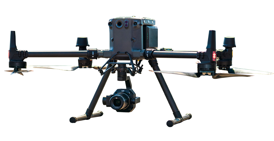
For transmission network operators requiring the highest inspection accuracy and the most comprehensive corridor data from each inspection flight the DJI Matrice 400 paired with the Zenmuse H30T multi-sensor payload and Zenmuse L3 LiDAR represents the complete transmission line inspection and corridor mapping capability.
The Matrice 400's Powerline Follow autonomous inspection mode uses the aircraft's obstacle sensing system to detect and follow the conductor along the transmission line autonomously maintaining safe standoff from the live conductor, adjusting altitude as the terrain beneath the line changes, and capturing consistent close-range inspection imagery of every conductor section, tower structure, and hardware component along the route without requiring the pilot to manually manage the aircraft's proximity to the energised infrastructure.
The Zenmuse H30T's 34× optical zoom identifies individual insulator string conditions, connector corrosion, damaged hardware, and bird nest accumulations on tower structures at the detail level that preventive maintenance decisions require. Its thermal camera simultaneously identifies the temperature differentials at conductor splices, connection points, and insulators that indicate developing electrical faults the thermal fault signatures that visual inspection alone cannot detect.
The Zenmuse L3 LiDAR maps the complete transmission corridor conductors, towers, and the vegetation beneath and around the corridor producing the 3D corridor model that vegetation encroachment analysis, minimum clearance distance calculation, and the formal corridor documentation that grid operators' asset management systems require.
For urban and peri-urban distribution network inspection where the compact footprint of the aircraft, the ability to operate from limited launch areas in built environments, and the integrated multi-sensor capability of a lightweight platform are the operational priorities the DJI Matrice 4T provides the portable inspection solution for Africa's urban utility inspection programmes.
At 1.2 kg, the Matrice 4T fits in a carry case in the inspector's vehicle. It carries visible, thermal, and telephoto cameras with a 1,800-metre laser rangefinder the sensor combination that identifies insulator damage, conductor condition, and the thermal signatures of overloaded distribution transformers and connection faults in urban distribution networks. RTK precise positioning georeferences every inspection image enabling the inspection findings to be accurately located on the asset management system's network map without requiring post-inspection GPS coordinate collection.
For grid operators managing transmission corridors across remote terrain where deploying inspection teams for every routine inspection cycle is both logistically complex and expensive the DJI Dock 3 autonomous inspection station positioned along the transmission corridor eliminates the crew deployment requirement entirely.
Routine inspection missions execute on schedule in DJI FlightHub 2 without any on-site personnel the Matrice 4D or 4TD launches, flies the pre-planned inspection route, captures the corridor imagery, returns to the dock, and uploads the inspection data to FlightHub 2 automatically. The grid operator's inspection team reviews the uploaded imagery in FlightHub 2 from the operations centre identifying findings, creating work orders, and dispatching maintenance crews only to the specific sections where the inspection data confirms action is required.
Kenya KPLC: 230 kV transmission network covering the Rift Valley's challenging highland terrain and the coastal distribution network. Drone inspection reduces the per-kilometre inspection cost that helicopter programmes impose on Kenya's largest utility.
Nigeria TCN and DisCo networks: Transmission and distribution infrastructure spanning the country's varied terrain from the Jos Plateau to the Niger Delta. Drone inspection enables the inspection frequency that Nigeria's distribution loss reduction programme requires without proportional increase in inspection budget.
Ethiopia EEPCO and EETC: Interconnection and distribution lines crossing highland mountain terrain where ground access is seasonally difficult and helicopter inspection frequency is budget-constrained. Autonomous Dock 3 inspection stations positioned along key corridors enable continuous seasonal monitoring.
Ghana ECG: Urban and peri-urban distribution network in a built environment that ground patrol teams navigate slowly. Matrice 4T compact urban inspection provides the access-constrained urban distribution inspection solution.
Compare DJI enterprise drone platforms, payloads and software for daily distribution inspection, transmission-line surveys, urban utility-network inspection and automated routine monitoring across Africa.
| Inspection Type | Platform | Payload / Software | Key Advantage |
|---|---|---|---|
| Daily distribution inspection |
DJI Matrice 30T
|
Integrated thermal and zoom camera | Rapid deployment, IP55 protection and repeatable waypoint missions |
| Transmission-line and corridor inspection |
DJI Matrice 400
|
Zenmuse H30T and Zenmuse L3 | Powerline Follow, long-endurance operations, high-zoom inspection and LiDAR mapping |
| Urban utility-network inspection |
DJI Matrice 4T
|
Integrated multi-sensor system | Compact platform with RTK positioning for detailed infrastructure inspection |
| Automated routine inspection |
DJI Dock 3 with DJI Matrice 4D / 4TD
|
DJI FlightHub 2 | Scheduled autonomous missions, remote fleet management and repeatable monitoring |
Mission Planning: Record waypoint inspection route once using DJI Pilot 2 Live Mission Recording or plan route in FlightHub 2 from LiDAR corridor model. Route replays identically on every subsequent inspection cycle
Data Collection: Aircraft follows inspection route autonomously. Thermal and visual imagery captured at defined intervals or triggered at specific inspection points.
Data Analysis: Review inspection imagery in FlightHub 2 or preferred asset management system. Thermal anomalies flagged for maintenance follow-up. Corridor model compared against previous survey for vegetation encroachment change detection.
Reporting: Generate inspection report with visual and thermal imagery, defect locations georeferenced against network map, and maintenance recommendations for each identified finding.
DJI enterprise drones equipped with zoom and thermal cameras can inspect transmission and distribution lines from a safe aerial distance. These inspections can help identify visible conductor damage, insulator defects, abnormal heat patterns at connection points, vegetation encroachment and structural issues on towers and poles. Drone-based inspection reduces the need for personnel to work close to energised infrastructure or difficult terrain.
Yes. A thermal payload such as the Zenmuse H30T can help identify unusual temperature differences at conductor joints, connection points, insulators and other electrical components. These thermal anomalies may indicate developing faults that are not visible in standard imagery. Thermal findings should be reviewed by qualified electrical inspection personnel and confirmed through the utility's established maintenance procedures.
DJI Dock 3 can support scheduled inspection missions along approved sections of a transmission or distribution corridor. A compatible DJI Matrice 4D or 4TD aircraft can follow a predefined route, capture inspection imagery and upload mission data to DJI FlightHub 2 for remote review. Utility teams can then assess the findings and dispatch maintenance crews to locations that require further investigation.

Fill in your details below and our team will get back to you
with a personalised quote.