

Africa's pipeline infrastructure is among the most geographically extensive and operationally challenging inspection environments on the continent. Nigeria's Trans-Niger Pipeline, Bonny Export Terminal pipeline network, and the hundreds of kilometres of gathering and export pipelines across the Niger Delta traverse terrain that combines dense mangrove vegetation, seasonal flooding, active communities, and the physical insecurity that makes ground patrol of pipeline right-of-way both dangerous and unreliable. Uganda's crude oil export pipeline crosses Albertine Graben terrain and the Lake Victoria catchment. Mozambique's LNG pipeline infrastructure serves the Rovuma Basin development. Kenya's petroleum pipeline runs from Mombasa through the highlands to Nairobi and beyond.
Each of these pipeline networks requires regular integrity inspection identifying the leaks, the third-party interference, the mechanical damage, the coating failure, and the right-of-way encroachment that represent the operational, environmental, and safety risks of a pipeline operating in an environment as challenging as Africa's.
Traditional pipeline inspection methods helicopter overflight, ground patrol on foot or in vehicles, and the periodic intelligent pig runs that assess internal pipe condition are all either too expensive at the required frequency, too slow for the linear distances involved, or too dependent on access conditions that African pipeline environments frequently make impractical.
DJI enterprise drone inspection provides the aerial pipeline corridor coverage capability that African operators need thermal leak detection, visual integrity documentation, right-of-way encroachment identification, and the automated continuous monitoring that high-risk segments demand.
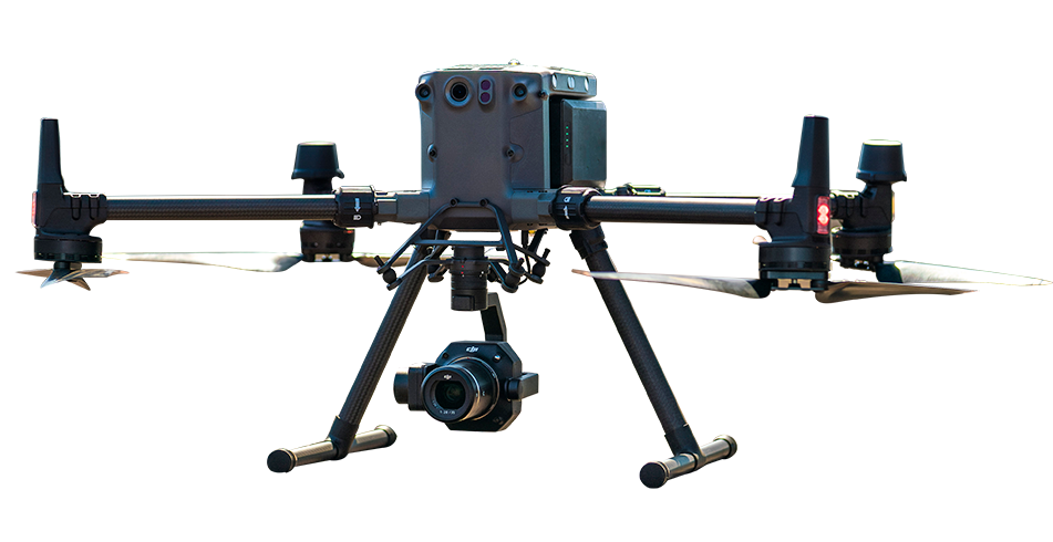
Hydrocarbon leaks whether gas from pressurised lines or liquid from crude oil or product pipelines produce thermal signatures that the Zenmuse H30T's thermal camera detects from aerial observation altitude. Liquid leaks produce surface temperature differentials from the evaporative cooling of volatile fractions. Gas leaks produce thermal disturbance patterns in the vicinity of the release point. Damaged insulation on buried pipelines produces surface temperature anomalies above the affected section. Each of these thermal signatures is detectable from the DJI Matrice 400 operating at standard corridor inspection altitude with the H30T thermal and zoom sensor package.
The Matrice 400's 59-minute flight time and 40 km transmission range enable corridor coverage significantly beyond what standard enterprise drones achieve per sortie covering the pipeline route in sequential corridor passes from a ground control position that does not need to move along the route as the inspection progresses. The zoom camera documents visual right-of-way conditions, encroachment by structures or agriculture within the legal exclusion zone, and the mechanical and surface conditions of above-ground sections, valves, and cathodic protection test points.
For pipeline corridor management programmes requiring formal as-built corridor documentation, vegetation encroachment assessment against minimum clearance standards, and the 3D terrain model that pipeline integrity risk assessment uses as its spatial foundation the Matrice 400 with Zenmuse L3 produces 100 km² daily LiDAR corridor coverage at 3 cm vertical accuracy.
The L3's 16-return capability penetrates the vegetation canopy above buried pipeline sections distinguishing the ground surface beneath the vegetation from the vegetation itself, and measuring the precise topographic profile of the corridor against the pipeline's documented depth of cover. Where erosion or external activity has reduced cover depth below the minimum required, the comparison between the current topographic survey and the design burial depth identifies the specific locations requiring cover restoration.
For the highest-risk pipeline segments river crossings, community proximity areas in the Niger Delta, active agricultural encroachment zones, and the pipeline sections with documented history of third-party interference the DJI Dock 3 autonomous station enables continuous scheduled aerial surveillance that detects developing problems before they become reportable incidents.
Daily or weekly scheduled thermal and visual flights over the protected pipeline segment provide the regular monitoring record that environmental compliance programmes, insurance requirements, and regulatory reporting demand. Third-party excavation within the pipeline exclusion zone, new structure construction, agricultural clearing, and suspicious activity patterns all detectable in the comparison between this week's corridor imagery and last week's baseline.
Nigeria Niger Delta: Third-party interference (tapping, illegal connections) is a documented operational risk affecting pipeline integrity and product losses. Drone surveillance combined with thermal detection provides the dual-layer monitoring that both integrity and security require.
Uganda EACOP: The 1,443 km East African Crude Oil Pipeline from Hoima to Tanga crosses diverse terrain including protected areas, agricultural zones, and river crossings the full-route corridor monitoring programme that this infrastructure requires is achievable through staged Dock 3 deployments along the route.
Mozambique Rovuma LNG: Onshore pipeline infrastructure for LNG export crossing the Rovuma Basin terrain remote inspection without daily crew logistics enabled by autonomous Dock deployment at key monitoring points.
DJI enterprise drones equipped with a thermal payload such as the Zenmuse H30T can help identify unusual temperature patterns along pipeline routes. These anomalies may be associated with escaping liquids, gas releases, damaged insulation or changes in the surrounding ground surface. Detected areas can be geotagged and referred for ground inspection and confirmation by qualified pipeline maintenance teams.
Daily corridor coverage depends on the aircraft, terrain, required image resolution, regulatory restrictions, visual line-of-sight requirements, weather conditions and the number of battery cycles available. Long-endurance platforms such as the DJI Matrice 400 can support extended corridor inspections, while multiple DJI Dock 3 stations may be used to monitor selected sections of a longer route. The final daily coverage should be calculated through a site-specific mission plan.
Yes. DJI Dock 3 can support scheduled surveys along approved pipeline corridors and exclusion zones. Comparing imagery from different dates can help identify new construction, agricultural activity, vegetation growth, access-road changes and other possible encroachments. Pipeline operators can then investigate these changes and take action according to their right-of-way management and safety procedures.

Fill in your details below and our team will get back to you
with a personalised quote.