

Africa is undertaking land-information programmes at continental scale, and traditional survey methods alone may not deliver the required coverage quickly enough with the tools traditionally available to it. Rwanda's nationwide land registration programme. Kenya's county spatial planning surveys. Tanzania's village land certification campaigns. Ethiopia's expanding rural land administration. Uganda's systematic demarcation programme. Nigeria's state-level land titling initiatives. Each of these national programmes faces the same fundamental challenge: the area to be surveyed is enormous, the timeline is politically and developmentally urgent, and the ground survey workforce and equipment available to do the work cannot cover the required area within the required time at a cost the programme budget can sustain.
Drone mapping changes that equation. Under DJI's stated test conditions, the Zenmuse P1 can cover up to 3 km² in a single flight and achieve 3 cm horizontal and 5 cm vertical absolute accuracy. The Matrice 400 with Zenmuse L3 can support large-area LiDAR programmes with daily coverage of up to 100 km². Actual productivity and accuracy depend on flight altitude, overlap, terrain, weather, positioning workflow, regulatory limits and processing settings.
Beyond land administration, Africa's mapping drone demand spans mining volumetric survey in Zambia and Ghana, construction earthwork monitoring across the continent's infrastructure development programme, forestry carbon stock mapping in Kenya and the DRC, archaeological site documentation in Ethiopia and Mali, and the infrastructure corridor surveys that road, rail, and powerline operators require for asset management and design.
Aerosmart Africa supplies and supports the complete DJI mapping drone ecosystem platforms, payloads, RTK ground-station hardware and DJI Terra processing software across 14+ African countries.
Land tenure security is the foundation of agricultural investment, urban development, and social stability across Africa. A farmer who does not have formal title to the land cannot access the credit to invest in it. A community whose land boundaries are not formally documented has no legal protection when development interest arrives. National land titling programmes across East and West Africa are attempting to address this at scale and drone survey is the technology that makes the required speed achievable.
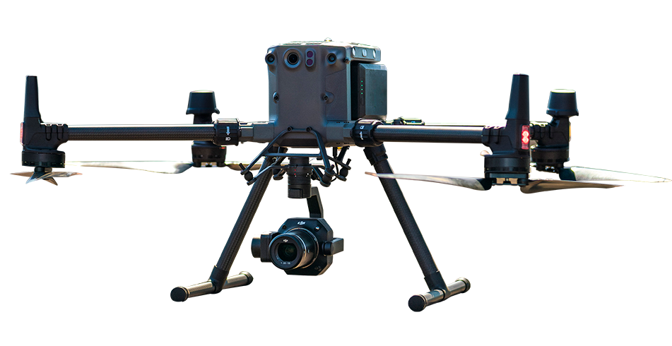
The DJI Matrice 350 RTK with Zenmuse P1 produces the centimetre-accurate orthophotos and 3D terrain models that cadastral survey boundary identification and formal registration require. With RTK-enabled workflows and appropriate quality control, systematic multi-flight programmes can cover large survey areas while reducing dependence on extensive ground-control placement. Ground checkpoints may still be required to validate accuracy and meet national cadastral standards.
Across Africa, land-administration and spatial-planning programmes increasingly use high-resolution aerial imagery and digital mapping to support boundary identification, community consultation and registration workflows. Drone data can accelerate field capture, but legal acceptance depends on each country's survey standards, licensed-surveyor requirements and land-registration procedures.
Drone mapping supports stockpile inventory measurement, open-pit geometry documentation, tailings-facility monitoring and haul-road condition surveys across Africa's mining sector. When paired with the Zenmuse L3, the DJI Matrice 400 can support large-area LiDAR programmes with daily coverage of up to 100 km² under stated operating conditions. At 120 m, DJI specifies L3 accuracy of 3 cm vertical and 4 cm horizontal RMSE; actual results depend on the mission environment and processing workflow.
Road design topographic survey, bridge condition documentation, dam construction progress monitoring, and urban infrastructure asset inventory across Africa's rapidly expanding infrastructure programme. DJI Terra can process mapping data locally, and an appropriate offline licence can support work at remote sites without continuous internet connectivity. This is useful for projects where mobile-data access is unavailable or unreliable.
LiDAR canopy penetration with the Zenmuse L3 can help produce the bare-earth terrain models and canopy height models that forest carbon stock assessment and REDD+ programme monitoring require. Illegal clearing detection through scheduled Dock 3 aerial monitoring. Commercial plantation inventory through photogrammetric crown delineation.
A complete aerial mapping workflow combining DJI enterprise aircraft, professional survey payloads, centimetre-level positioning, data-processing software and fleet-management tools.
| Component | Product | Function |
|---|---|---|
| Survey Platform | DJI Matrice 350 RTK / DJI Matrice 400 | Enterprise aircraft platform designed to carry professional surveying, mapping and inspection payloads. |
| Photogrammetry Payload | DJI Zenmuse P1 | 45 MP full-frame photogrammetry camera with interchangeable 24 mm, 35 mm and 50 mm lenses for high-accuracy aerial survey missions. |
| LiDAR Payload | DJI Zenmuse L2 / DJI Zenmuse L3 | Captures dense point-cloud data for terrain modelling, vegetation penetration, corridor mapping and detailed 3D reconstruction. |
| RTK Base Station | DJI D-RTK 3 Multifunctional Station | Provides centimetre-level positioning reference data to improve the accuracy and reliability of aerial survey operations. |
| Processing Software | DJI Terra | Processes aerial data into orthomosaics, digital surface models, point clouds, 3D models and vegetation-analysis outputs. |
| Model Editing | DJI Modify | Refines, repairs and prepares reconstructed 3D models for professional review and client-ready project delivery. |
| Fleet Management | DJI FlightHub 2 | Supports cloud-based mission planning, multi-site coordination, live operation management and centralised fleet oversight. |
No GCP dependency: In remote African survey environments where establishing and measuring ground control points requires additional survey crew and equipment deployment, the D-RTK 3 + Matrice 350 RTK + P1 combination can achieve high survey accuracy under suitable conditions while reducing dependence on GCPs, removing the pre-flight field preparation that makes frequent survey visits expensive.
Offline processing: Many African survey sites, including mine concessions, agricultural estates and rural project areas, have limited connectivity. DJI Terra's offline-licence option can support local processing at the field base without continuous cloud access.
African coordinate systems: DJI Terra supports custom and commonly used coordinate-reference workflows. Project teams should confirm the required datum, projection, geoid model and national survey specifications before producing final GIS or cadastral deliverables.
DJI enterprise drones equipped with photogrammetry or LiDAR payloads can capture high-resolution geospatial data across large areas. Survey teams can process this data into orthomosaics, digital surface models, point clouds, elevation models and detailed 3D terrain models for cadastral surveys, infrastructure planning, construction monitoring, mining and environmental projects.
Survey accuracy depends on the aircraft, payload, flight altitude, RTK or PPK workflow, ground-control strategy, terrain and processing settings. Under suitable operating conditions, the DJI Zenmuse P1 can achieve approximately 3 cm horizontal and 5 cm vertical absolute accuracy when used as part of a properly planned survey workflow.
The DJI Matrice 350 RTK with the Zenmuse P1 is a strong choice for high-accuracy photogrammetry and general land surveying. For larger LiDAR projects, vegetation mapping, corridor surveys and terrain capture beneath tree canopy, the DJI Matrice 400 with the Zenmuse L3 may provide greater coverage and improved long-range data collection.
Coverage varies according to flight altitude, ground sample distance, image overlap, wind, terrain and local aviation restrictions. In suitable survey conditions, a Zenmuse P1 workflow can cover approximately 3 km² in one flight, while the Zenmuse L3 can cover up to approximately 10 km² in a single flight at a 300 m operating altitude.
Drone mapping can provide detailed orthorectified imagery, terrain data and boundary-reference information that supports land-administration and cadastral projects. However, final acceptance for legal land registration depends on the national surveying standards, required accuracy, licensed-surveyor approval and land-registration regulations of the relevant African country.
Photogrammetry creates maps and 3D models by analysing overlapping aerial photographs. It is suitable for visible terrain, buildings, stockpiles and construction sites. LiDAR measures the distance between the sensor and the ground using laser pulses and is generally better suited to dense vegetation, complex terrain, forestry and applications requiring detailed point-cloud data.
DJI Terra supports offline-license versions that can be used for local processing without continuous internet connectivity. This can be useful at mines, agricultural estates, infrastructure sites and rural survey locations where network access is unavailable or unreliable. The appropriate offline licence must be configured before deployment.
Depending on the payload and processing workflow, survey teams can produce orthomosaic maps, digital surface models, digital terrain models, contour data, classified point clouds, textured 3D models, stockpile measurements, vegetation information and engineering-ready geospatial outputs.

Fill in your details below and our team will get back to you
with a personalised quote.